
Find what's going wrong on your site, while there's still time to fix it.
Landex grounds every element on your site in a rich spatial model, then reasons across the field and the documents that govern it to surface what a rep would never have time to catch.
Landex: long reasoning over your entire site, grounded element by element, surfacing what costs you money while there's still time to act.
Every element on site, grounded in a rich spatial model and keyed to the install record that governs it.
No one can hold the whole site in their head.
The context is more than any rep can take in.
A commercial project generates more drawings, submittals, RFIs, meetings, and site conditions than one person can hold at once. The owner's rep does the best they can on the walks they have time for. The problems that matter live in the gaps between all of it, exactly where a human runs out of attention.
The record is fragmented and unlinked.
Drawings sit in one system, submittals in another, meeting notes in an inbox, the field in someone's phone. Nothing connects a thing said in a meeting to the wall it was about. So the synthesis that would surface a problem never happens, because no one can see across all of it at once.
Caught late, every problem is expensive.
An over-install, a substitution, a coordination clash, a slipping scope. Caught while the trade is on site, it is a same-week fix. Caught at closeout or after a failure, it is a dispute, a delay, or an opening you cannot get back into.
The tools on site give you a picture. Landex gives you something you can reason over.
Reality-capture tools built for the general contractor render a shallow model, a clay shell with light tags on top, this is an HVAC system. That is a picture of the site. It is not a substrate a reasoning model can think across, and the record lives inside a platform the GC pays for. When the GC demobilizes, that access leaves with them.
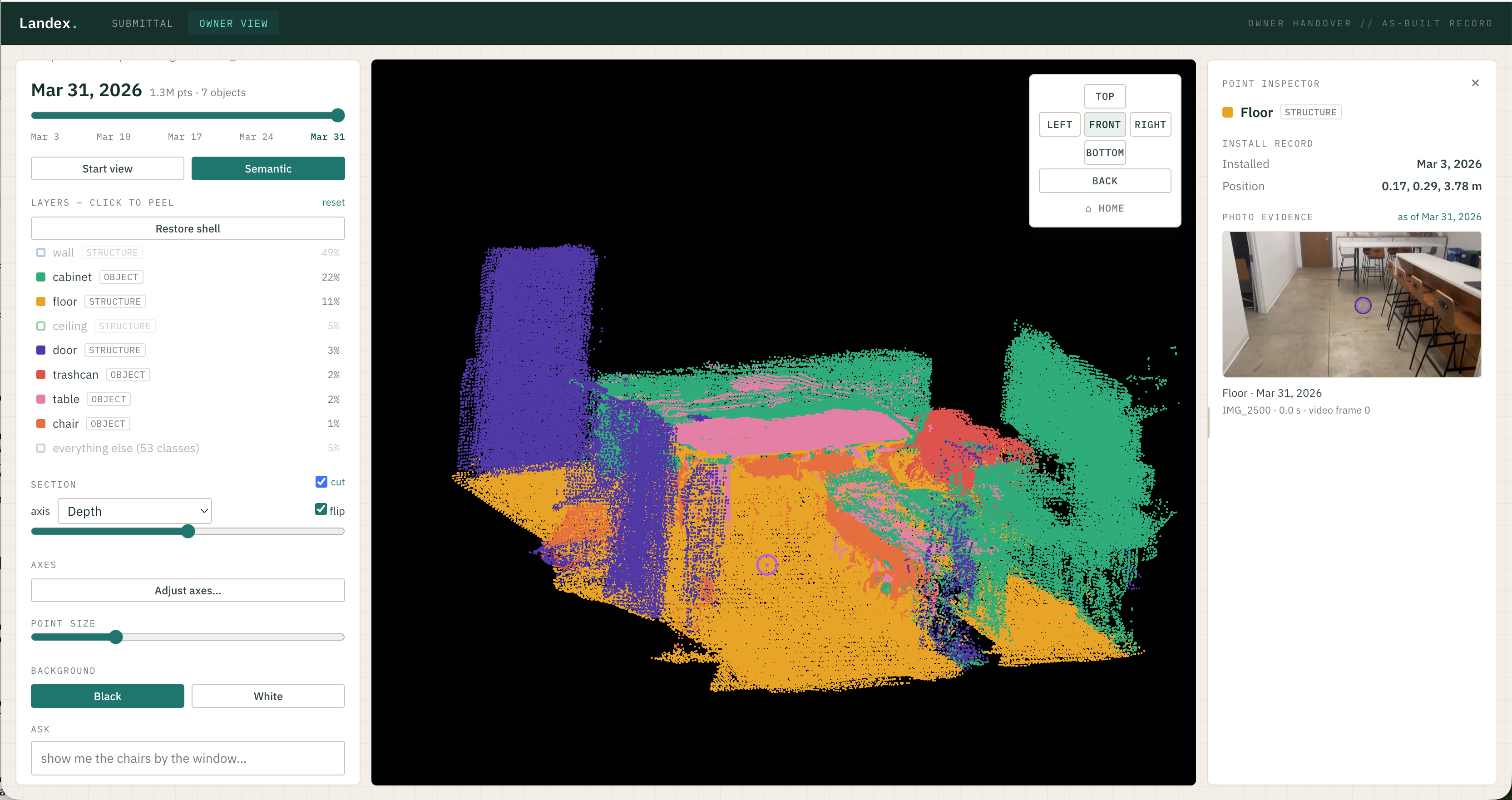
Landex grounds every element in a rich spatial model, semantically, keyed to the real component and connected to the documents that govern it. That grounding is what makes long reasoning across the whole site possible. It is the same job your owner's rep already does, taking in the site walks, the drawings, the submittals, and the meetings and hunting for what is wrong, except done across everything at once, at a scale no person can hold in their head. Think of how a strong case file lets a lawyer reason across years of documents and pull out exactly what bears on the matter at hand. Landex does that for a construction site, and it is built for the owner's side of the table: an asset you own, not a login you rent for the duration.
The people building Landex.
A small team that has spent enough time around real projects to know where the record breaks down.

Allen Chen
Co-founderAllen graduated from MIT in 2026 with a degree in mechanical engineering, where he worked on robotics. He works on Landex to build software for the physical world of construction, which almost no tools touch today.
allen@landexsystems.com
Auddithio Nag
Co-founderAuddithio earned his CS masters at Stanford in 2026, with research in machine learning and geospatial analysis spanning satellite flood prediction and medical imaging. He works on Landex because reading a construction site from sensor data is the same problem as his past work on 3D scene understanding.
auddi@landexsystems.com
Beckett Devoe
Co-founderBeckett graduated from MIT in 2026 studying AI and decision making, and built computer vision models for the physical world, from shellfish health at MIT Sea Grant to ocean research in Norway. He works on Landex to point those same tools at the things people build.
beckett@landexsystems.comWhoever already walks the site just films what they are looking at. Landex turns it into context you can reason over.
No rig, no new person, no new field behavior. The walkthrough already happens, now it is captured on the phone in their pocket.
Whoever already walks the site just films it
Someone is already walking the job, your super, your PM, your rep. They point their phone at what they are already looking at, before the wall closes, during install, and after. No 360 rig, no dedicated walker, no trades to coordinate. The walk already happens; now it is captured.
Landex grounds it in a rich spatial model
Every element is identified, keyed to the real component, and embedded semantically in a model of the site. This is the substrate. It is what separates a picture of the job from something a reasoning model can think across.
Landex reasons across the full context
Landex reads across the field and the documents that govern it, the drawings, the submittals, the meetings, as one connected context. It surfaces the problems and inefficiencies that cost the owner money, reconciling what was installed against what was approved wherever they disagree.
Your rep acts on it while the job is live
The findings land while the trades are still on site, when a fix is cheap. Your rep drives real gains against schedule and cost, on the same walks they already do. The record you build along the way is yours to keep.
Surface it while the job is live. Keep it for the life of the asset.
Surface.
While the project is building, Landex reasons across your whole site and surfaces the kind of catch that today only comes out of a two-hour meeting with every party in the room, if it comes out at all. Every issue found early is points off your budget.
Accept.
Because the record was built element by element as the work went in, handoff is something you prove, not something you scramble for. Sign off against a reconciled record instead of an inbox.
Operate.
From day one of operations, find the exact valve, damper, or conduit run behind the wall without opening it. The as-built you built during construction is the map for the next thirty years.
Prove.
When a system fails years later, you already hold the record of exactly what was installed, at element grain, captured the day it went in.
One system, one live job. Prove it where it bites first.
or email allen@landexsystems.com